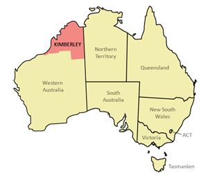
– a joint exhibition with painter,Tom Montgomery, about the threat of industrialisation of the magnificent Kimberley region in NW Australia.
Courtesy Martyman
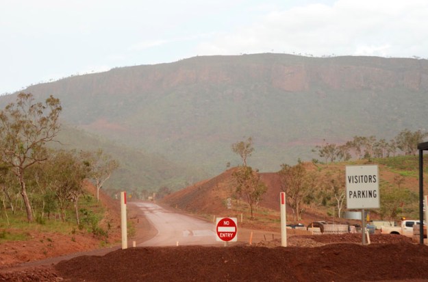
When: May 21 – June 9, St Heliers Gallery, Abbotsord Convent Arts Precinct, Melbourne
Opening Night: Fri May 24, 5 – 8 pm.
Official Closing Address: June 7 at 10.30 am. Dr. Bob Brown (ex Greens Leader, ex Franklin River Campaigner, current Bob Brown Foundation creator, Save The Tarkine Patron) tells us why he thinks The Kimberley is so important. Thanks Bob.
Why: Despite Woodside dropping its plans for the world’s largest Liquefied Natural Gas (LNG) processing plant at Walmadan (James Price Point), WA Premier Barnett has declared he is continuing the compulsory acquisition process of the land around Walmadan. Industrial Invaders will keep coming in the months/years ahead. There is too much priceless culture and wilderness to lose…millions of years of creation and 40,000 + years of Aboriginal culture…in exchange for a predicted 50 years of mining. Madness! Keep Kimberley always in your hearts & minds.
Thanks to the following: Elder and Law Boss, Phillip Roe and The Goolarabooloo Mob – traditional custodians of the Walmadan area; The Awesome Foundation for their funding support; The Bob Brown Foundation for providing Bob; Rathdowne Cellars for discounted wine.
Bob Brown’s Closing Address
Thanks to Dave Meagher and Singing Bowl Media for filming and editing this.
The Exhibition

NB. all photographs were taken from the main highway that traverses The Kimberley (except those at Walmadan/James Price Point). Just imagine what you’d get if you got into the wild and tasty innards!)
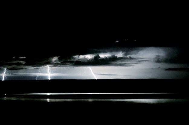
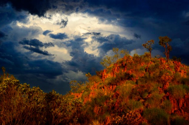
#1 – ‘Electrical Storm’
Dec 31, 2012: 22:52
Latitude, Longitude: -15.450886, 128.11904
Here, from Five Rivers Lookout, in the Kimberley’s NE, one can see five rivers flow into the Cambridge Gulf: The King; The Durack; The Pentecost; The Ord and The Forrest. I spent four nights living up here after the local policeman’s wife suggested I do so, despite the ‘No Camping’ signs. On the morning of day five, the ranger asked me kindly to move on.
Five Rivers Lookout has been listed as one of the world’s top lookouts and, for once, I’d have to agree. However, the recent addition of the Kimberley Metals Group’s iron-ore loading yard is a worrying sight. (refer #2)

#2 – ‘Iron-Ore’
Jan 1, 2013: 21:19
Latitude, Longitude: -15.44023, 128.114946
Kimberley Metals Group runs this iron-ore loading yard, set amidst a sensitive mangrove and mudflat eco-system. Council signs in the area ask people not to drive on the mudflats, yet it is somehow ok to build this industrial site. The ore is delivered from KMG’s Ridge’s Mine (refer image # 10) about 165km away. Road-trains up to 53 metres in length travel in both directions EVERY 20 minutes for approximately 20 hours per day. And this is a small-scale mine. If the Kimberley becomes the industrial hub Premier Barnett wants it to be, this will be catastrophic.
A few days later I was camping about 30 km from this yard at a spot called The Grotto (a gorge and waterfall) which is a few km off the main highway. Apart from nature I could hear nothing else…except the road-trains.
Tidal flats and mangrove forests are important ecosystems. They usually support a large population of wildlife and are often of vital importance to migratory birds, crabs, molluscs and fish. In the UK mudflats have been classified as a Biodiversity Action Plan priority habitat. The maintenance of mudflats is important in preventing coastal erosion. However, mudflats worldwide are under threat from land claims for development, dredging due to shipping purposes, and chemical pollution.
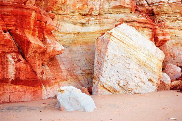
#3 – ‘The Blood-Stained Cliffs of History’
Feb 5, 2013: 12:07
Latitude, Longitude: -17.466437, 122.152138
These incredibly beautiful coloured sands and stone are just a couple of km north of Walmadan (James Price Point), the site proposed for the world’s largest ever Liquefied Natural Gas Processing Plant – the primary reason I undertook this project. Fortunately the proposal has been abandoned by the main company, Woodside Petroleum. However Premier Barnett is determined to build a massive industrial port in The Kimberley and he is still considering using James Price Point.
If he is successful, a port would open the floodgates to industrial development, providing an export point for companies that cannot otherwise afford to begin mining. It is vital that a port is not built anywhere in The Kimberley. Over the past ten years there has been a 500% increase in mining leases across the Kimberley. Lack of a port is the main thing stopping many of them from beginning operations.
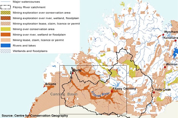
A map of current mining exploration in The Kimberley – an horrific prospect for this incredible wilderness zone.

#4 – ‘Ghost Dogs at the Cliffs of Walmadan’
April 10, 2013: 20:04
Latitude, Longitude: -17.489176, 122.142686
This is taken from James Price Point, looking south along what Premier Barnett claims is an “unremarkable piece of coastline” in a cynical attempt to fool the general public based on an ‘out of sight, out of mind’ approach. He knows full well that most Australians will never see this area for themselves. It’s strikingly similar to former Tasmanian Premier, Robin Gray, who described The Franklin River as “a leech ridden ditch” during his attempts to dam The Franklin in the early 80’s. Post the campaign that ‘ditch’ became part of the South-West World Heritage Area. Post his political career, Gray went on to be Director of Gunns Limited, famous for wood-chipping Tasmania’s old-growth forests. I wonder where Barnett will end up?

#5 – ‘And a Lion I Did See’
April 10, 2013: 20:15
Latitude, Longitude: -17.489176, 122.142686
Rock formations along the “unremarkable piece of coast” at Walmadan. These rocks sit only metres from some of the world’s most significant dinosaur footprints, next to a humpback whale migratory path, and on a sacred Aboriginal Songline. The Lurajarri Trail, established by Aboriginal Elder and Order of Australia recipient, Paddy Roe, passes along here. It offers Aboriginal and non-Aboriginal people from across the world a chance to learn another way of being, bridges the gap between cultures, teaches bush-tucker and bush-medicine skills, and highlights the Aboriginal understanding regarding the reciprocal nature of the relationship between humans and the earth. All of the above would’ve been destroyed if the LNG plant went ahead.
NB. A songline forms part of The Song Cycle which “…is an oral heritage map. Its songs contain codes of behaviour fundamental to sustaining the balance and well-being of the land and its people.” – Jeanne Brown, artist/environmentalist from Melbourne who has been living with the Goolarabooloo Community intermittently since 1992, invited up initially by the late Paddy Roe OAM to help with the documentation of cultural heritage, including functional plant use, significant sites, language and seasonal knowledge of place. Refer the song cycle for more info.
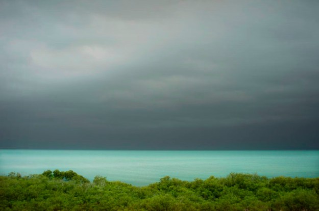
#6 – ‘Advancing Storm’
Jan 19, 2013: 20:33
Latitude, Longitude: -17.967657, 122.239082
Looking across Roebuck Bay from Broome. Roebuck Bay is an important migratory zone for waders (shorebirds). The bay’s wader feeding habitats and roosting sites have been identified by BirdLife International as a 928 km2 Important Bird Area (IBA).
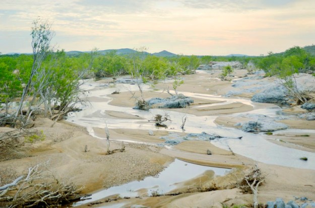
#7 – ‘Meandering Streams’
Jan 5, 2013: 09:21
Latitude, Longitude: -16.793298, 128.28105
These beautiful meandering streams to the NE of Halls Creek will be unrecognisable when the Wet Season storms arrive, turning them into a massive river. The Kimberley has 33 of Australia’s 48 listed Wild Rivers. Wild rivers are waterways where biological and hydrological processes continue without significant disturbance. The river systems bring nutrients and freshwater inundations into coastal saltwater bays and estuaries and provide nurseries for fish and crustaceans.
#8 – ‘Day’s End’
April 1, 2013: 19:46
Latitude, Longitude: -17.497987, 122.147021
The sun begins its daily farewell over the monsoon vine thickets (MVT) at Walmadan. The MVTs are remnant rainforest and were recently listed as ‘endangered’ under the Environmental Protection Biodiversity and Conservation Act. They form part of the sacred Songcycle for the Goolarabooloo people and have one of the highest densities of food and medicinal plants in Australia. They are also a vital source of timber for ceremonial implements and provide habitat and safe passage for the wildlife of the area.
This section pictured would’ve been destroyed by the gas plant. It was taken at the end of a Mayi (bush-tucker) walk run that day by the Goolarabooloo, the traditional custodians of this land who were always against the LNG proposal.

#9 – ‘Iron Storm’
Jan 5, 2013: 20:42
Latitude, Longitude: -18.244136, 127.699971
Ten minutes of ridiculously beautiful light, storm clouds and rocks converged here one evening. I was on my way to Caroline Pool, near Halls Creek (known as ‘Hells Crack’ to some), when I rounded a bend and there this was. I came to a sudden halt, shot a few frames and then soaked it up as best I could. This scene will always stay in my mind, like The Kimberley itself.
#10 – ‘Off Limits – Ridges Mine – a Wilderness No More’
Jan 4, 2013: 18:04
Latitude, Longitude: -16.652781, 128.24897
This is KMG’s ‘Ridges Iron Ore Project’. The iron-ore is loaded into road-trains and every 20 minutes one then begins the 165 km trip to the loading yard (refer image # 2) where it is stock-piled, then conveyed to barges in Cambridge Gulf, carted upstream to waiting mother-ships and then shipped to the Hong Kong buyer. This is a relatively small-scale mining operation.
Numerous mining companies of much greater size are just waiting for a massive port to be built (by someone with the money, possibly taxpayers) in order to begin large-scale operations across The Kimberley (refer map). These operations will result in massive environmental destruction, habitat loss, species loss, cultural loss, various forms of pollution and social upheaval. Currently the northern section of The Kimberley has NO recorded mammal extinctions (unlike anywhere else in Australia). On the contrary, new species of flora and fauna are discovered on a regular basis.
The Kimberley environment has a right to exist, just as we do. We have other ways and means at our disposal.
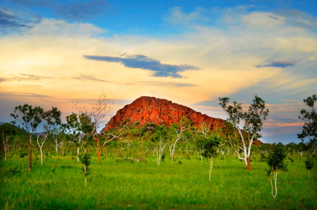
#11 – ‘Iron Mountain’
Jan 3, 2013: 20:54
Latitude, Longitude: -15.9598, 128.420048
On passing through a cutting on the Great Northern Highway, this mountain appeared to my left, amidst the savannah plains at dusk. The Kimberley is one of the world’s last remaining savannah wilderness regions. A savannah is a grassland ecosystem characterised by the trees being sufficiently widely spaced so that the canopy does not close. The open canopy allows sufficient light to reach the ground to support an unbroken herbaceous layer consisting primarily of grasses.
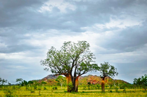
#12 – ‘Boab Cluster’
Jan 4, 2013: 19:16
Latitude, Longitude: -16.69979, 128.252506
On the side of the highway about 200 km NE of Halls Creek this cluster of Boabs huddled together on the savannah before the distant range. I was so taken by this scene that I pulled off onto a roadside levee where I watched them under the setting sun before sleeping there for the night.
#13 – ‘Paradise Once Lived Here’
Dec 27, 2012
Latitude, Longitude: -15.77973, 128.740239
Industrial Facility, Kununurra, far NE Kimberley.

#14 – ‘The Bastion’
Jan 1, 2013: 21:23
Latitude, Longitude: -15.450886, 128.11904
Looking towards the mouth of the Ord River at Cambridge Gulf, far NE Kimberley.

#15 – Morning Glory’
Apr 8, 2013: 07:55
Latitude, Longitude: -17.500548, 122.145216
Morning Glory is traditionally used as a bush medicine, a bandage of the ground vine leaves being applied as a poultice. Sections of vine could also be rubbed, bent and bruised, and then tied around the head to relieve headaches and migraines.
I slept out here on the dunes (at Walmadan, the epicentre of the proposed Liquefied Natural Gas processing plant) for about five weeks, under a star-filled sky, sometimes with an Indian Ocean breeze rolling up the dunes to keep the mozzies at bay, sometimes with the breathless humid night air which left me dripping with sweat and made me a feast for the mozzies, and occasionally with a stormy inland easterly tearing at my covers.
Sales:
The above images are available for sale in the following formats:
A) 30 x 40 cm framed prints on metallic paper;
B) 120 x 84 cm unframed prints on 160 gsm matt paper;
C) Special 100 x 70 cm framed Limited Edition prints of ‘Iron Storm’ and ‘Electrical Storm’ on metallic paper (Edition limited to 5). NB. ‘Iron Storm’ and ‘Electrical Storm’ are also available at the other sizes as an open edition as listed in A) and B) above.
Tom’s Watercolours
Artist Statement:
I am 23 year old conservation artist based in beautiful Broome, Western Australia. My passion is exploring the Kimberley’s pristine environment from its spectacular gorges, waterfalls, cave systems, isolated islands and pockets of lush rainforests. With no recorded extinction, the Kimberley is the Noah’s arch of northern Australia’s biodiversity. A complex and immense landscape abundant with unique wildlife.
Rugged terrain makes the Kimberley largely inaccessible, thus holds the key to its remarkable preservation. Rocky gullies have so far sheltered sensitive areas from most external influences such as raging fires and over grazing from livestock. At the very heart of this pristine wilderness we unearth its greatest threat, untapped resources.
A proposition that comes with a choice that puts the Kimberley’s future on the line. If we say nothing against industrialisation our limitless thirst for resources will decide the verdict.


Notes regarding the above portrait image:
The tedious work that Tom puts into his watercolours has transferred into the same level of discipline when it comes to creating his own unique portrait style. A style that seeks to capture the real spirit of the Kimberley people and their connection to the land.
This is achieved by collecting ochre pigments from the local landscape to enhance his work. When drawing inspiration from the vibrant colours of the Kimberley, Tom observes the elements as the perfect painter’s pallet
Pindan Technique
He first uses an interesting preparation technique that involves burying the cotton paper in raw pindan earth in specially selected locations. Once the pindan hues are embedded in the paper any excess dirt is rubbed away with a rag.
Dark tones are acquired by using charcoal from the camp fire which is ground up and applied to the paper with a firm brush and smudge sticks. Light values are then brought forth by removing the pigment from the paper with a kneedable eraser. Finally the work is fine-tuned with graphite pencil. Over the following days the pindan is slowly tamed and the Kimberley character begins to emerge from what was once dust.
Copyright Charlie Sublet and Tom Montgomery.
